Very little of medieval Dublin survives above ground which makes this type of map even more important. Part of the Irish Historic Towns Atlas Series this map, and the accompanying historical outline, cartographic guidelines and index of sites, provides a useful visual and geographic guide to the medieval remains of the city.
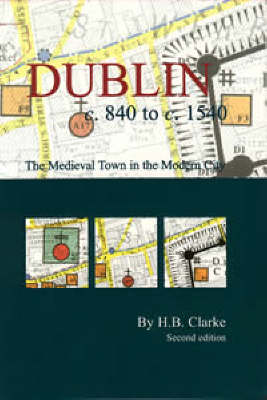
Very little of medieval Dublin survives above ground which makes this type of map even more important. Part of the Irish Historic Towns Atlas Series this map, and the accompanying historical outline, cartographic guidelines and index of sites, provides a useful visual and geographic guide to the medieval remains of the city. Juxtaposing the medieval remains with features of the modern city, this map will be of particular importance to archaeologists, historians, cartographic historians, and modern planners and developers. The map was first created by H B Clarke in 1978, and is here updated and corrected.
This map offers a visual insight into medieval Dublin. The results of historical research and archaeological exploration are revealed in the form of bright colours and symbols representing features from the city's Gaelic, Viking, Hiberno-Norse, Anglo-Norman and Anglo-Irish past. The information is superimposed on a more modern base map so the hidden medieval urban landscape can be put in context. The map is complemented by a detailed index and introductory booklet.